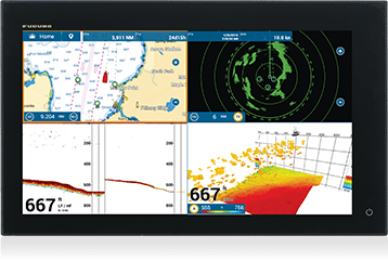
TZT19F
NAVNET TZTOUCH MULTIFUNCTION DISPLAY
Multi Function Display NavNet TZtouch3 19″
DESCRIPTION
HIGH PERFORMANCE QUAD CORE PROCESSOR
NavNet TZtouch3 offers four different types of models. The 19-inch TZT19F model is all-glass, multi-touch and equipped with IPS technology capable of providing sharp and brilliant images from any angle. All models incorporate a quad-core processor that pushes TimeZero technology to its maximum potential, offering a split monitor into four portions with a response speed never seen before.
INTEGRATED TRUECHO CHIRP™ MODULE & CONTINUOUS WAVE TRADITIONAL
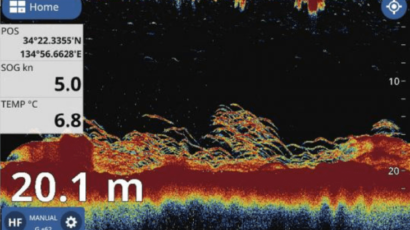
Every NavNet TZtouch 3 includes a built-in 1kW TruEcho CHIRP™ Sonar (the equivalent of the DFF1-UHD Black Box Sonar 1 kW).
MODERN AND REFINED GRAPHIC INTERFACE
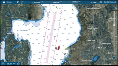
Improved software, easy and intuitive, allows immediate access to the main functions for simpler and more effective use thanks to the innovative access to functions with a single touch and scrolling from the edges.
The size of the fonts, icons and scale can be changed by the user to ensure maximum comfort of use.
Navigation data boxes are accessible from any page, while a data box is dedicated to the display in use.
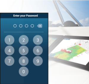
SECURITY CODE
Your data is always safe thanks to the innovative PIN code lock function; it is possible to set a password with a 4-digit code which will be requested when the instrument is switched on, to keep the personal database, points, routes away from the bad guys.
RADAR – POWER AND RESOLUTION AT THE HIGHEST LEVEL
Maximum power and incredible target detection offered by the DRS-NXT (SSD solid state) & DRS-X_CLASS (Magnetron) Radar.
Exceptional long-range performance, coupled with outstanding close-range detection and resolution.

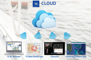
FURUNO & TIMEZERO ECOSYSTEM WITH TZ CLOUD
The new TZT3 firmware version introduces the use of a new system to manage and synchronize “User Objects” in the cloud. This term indicates all objects of particular interest to the user such as tracks, waypoints, routes, etc. Also, new types of user objects such as border areas (lines or circles) are now available.
MARINE APPLICATIONS
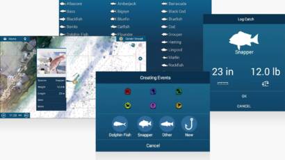
You invested a lot of effort into finding a good fishing spot and guess what, it paid off! Wouldn’t it be nice to save a note about your prey and its size? Now you can do it with your TZtouch3 while recording a mark. Choose the species, enter the length and weight and then take a picture with your phone. Showcase this branding on tablets and phones with the TZ First Mate app, TZ PC software or TZ iBoat.
DFF3D – 120° PORT SIDE TO STARBOARD
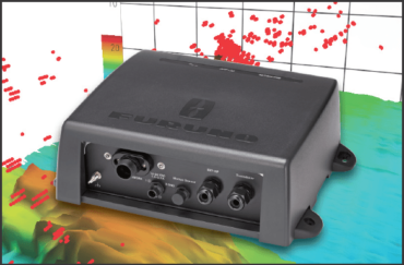
All the tracking power of the Multi Beam DFF3D with 120° port to starboard at depths up to 200m (300m directly under the boat) to get you a perfect fishing machine and find the fish you would normally miss.
PBG – CUSTOM BATHYMETRY GENERATOR
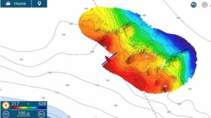
Using the DFF3D multibeam echosounder, captains can create their own high-precision bottom maps extremely quickly and easily, thanks to a 120-degree beamwidth. Instead of a single resonance point per pulse, as seen on other manufacturers’ MFDs, the DFF3D produces over 50 resonance points per pulse, allowing for fast and efficient custom mapping of the seabed. The TZtouch3’s PBG (available with V2.01 software and above) incorporates stabilized inertial calculations and tidal compensations resulting in highly accurate bottom mapping previously only available with elaborate, dimmable sound systems. The PBG developed by Furuno is precise and intuitive; simple to use, with detailed bottom bathymetry obtained quickly, easy to understand at a glance.
FISH-IT/DRIFT-IT: REVOLUTIONARY TECHNOLOGY FOR ANGLERS
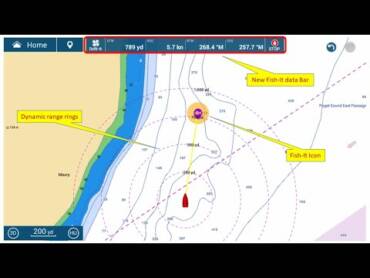
This feature is designed to save anglers time and fuel while maximizing their fishing opportunities. By touching a spot on the map, such as a wreck, man-made structure, or anywhere the operator wishes to fish, the operator has the option to activate “Fish-It”. “Fish-It” creates a “fishing starting point” that, when activated, causes dynamic scaled circles to appear around the Fish-It point. A temporary line is drawn between your vessel and the location of the ‘Fish-It’ point and a ‘Fish-It’ data bar appears at the top of the screen with the information. “Fish-It” remains active in this position until the stop button on the data bar is pressed. Once a “Fish-It” commercial is active, the user will have the option to activate the “Drift-It” feature. This new never-before-seen feature will automatically create a drift point to ensure you hover directly over your “Fish-it” fishing spot.
FOLLOW IT!
Follow-It allows users to leverage PBG (Personal Bathymetric Generator) data from their DFF3D multibeam echosounder. Follow-It instantly creates a constant depth path to navigate a specific depth profile. With a single click, Follow-It creates a white line on the PBG graph indicating constant depth. By clicking on the line, the angler can instantly turn it into an active course and send it directly to his NavPilot autopilot. The NavPilot will follow the depth path around a bottom feature. By following specific depth contours, anglers can keep the lure level with the fish while trolling without having to constantly adjust the reel seat.

CHIRP SIDE SCAN
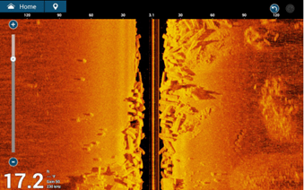
In deep water (range: up to 200m) and shallows, view detailed bottom structure in high definition and find those not listed on charts, view schools or individual fish before casting the lure. The Furuno CHIRP Side Scan already integrated into your NavNet TZT12F, TZT16F and TZT19F simply requires the connection of the new SS904 probe (220-240kHz / 300W / T / 10m 12-pin cable). The image will also be available on TZT9F and TZT2BB networked with NavNet TZT12F, TZT16F and TZT19F.
PRODUCT BENEFITS
It has all the power you wanted and much more
• Powerful quad-core processor for lightning-fast command responses
• Built-in TrueEcho CHIRP module Dual Channel, 1kW power & Continuous Wave Echosounder
• 2/3/5kW* high power amplifier TruEcho DI-FFAMP
• NXT Full Power Solid State Doppler Radar 100W & 200W
• Compatible with DFF3D Multi-Beam Max depth sonar 300m & Sidescan up to 200m
• Password lock – a password is required to access your TZT3 at startup
*Connecting a transducer 5kW or 10kW requires BT-5, otherwise output power is 3kW
FEATURES
Display
Type: Color TFT IPS (In-Plane Switching) LCDScreen 18.5″ polich Wide
Resolution: FHD 1920 x 1080
Brightness: 900 cd/m2
Map/Map Alarm
: MapMedia mm3d chart (C-MAP/Navionics/NOAA)
Memory Capacity: Track 100,000 points, Puto/MOB 30,000 points, Course 200 with 500 points per route
Alarm: Anchor, XTE, Depth*, Speed, Sea surface temperature*, Trip Distance, Fuel gauge* (*option)
RADAR
Orientation mode: Head-up *, North-up* (*compass data required)
Target Tracking: 30 ARPA Targets (DRS X-Class), 100 ARPA Targets (DRS-NXT)
Radar Alarms: Guard Zone, CPA/TCPA, Trigger, Video, Azimuth, Heading Line
ECHO SOUNDER
Frequency: Continuous Wave: 50/200 kHz and CHIRP: 40 kHz to 225 kHz
Output Power: 300/600 W or 1 kW* (*MB1100 Matching box required).
Range: 2-1, 200m, Displacement: 0-1200m
Display Modes: ACCU-FISH™, A-Scope, Auto (Fish/Cruise), RezBoost™, Bottom Discrimination, TruEcho CHIRP™
INTERFACES
CAN bus/NMEA2000: 1 Port
NMEA0183: 1 Output Port Output
: AAM, APB, BOD, DBT, DPT, GGA, GLL, GNS, GSA, GSV, RMB, RMC, RTE, TTM, VDM, VTG, WPL, XTE, ZDA LAN: 2 Ports (
100 BASE-TX)
USB: 1 Port (USB2.0) for touch monitor and
Video I/O control
- Video INPUT: 2 Ports (NTSC/PAL) and 1 HDMI port 1920 x 1080p
- Video OUTPUT: 1 Port (HDMI 1080p)
AUX I/O: 2 Ports and 1 Output Buzzer
Port SD Card Slot: 1 Micro SD Slot (SDXC, Rear), Two SD Card Slot Unit: Model SDU-001 (Optional)
Wireless LAN: IEEE802.11b/g/n, Transmission frequency: 2.412 to 2.462 GHz, 11dBm max
Transducer: 1 Port
ENVIRONMENTAL CONDITIONS
Ambient temperature (IEC60945): -15°C to +55°C
Relative humidity: 93% or less at +40° C
Degree of protection: IP56
POWER SUPPLY
12-24VDC
4.7 – 2.3A
CONTENT
TZT19F Multi Function Display 19″ x 1
Gray Silicone Cover x 1
Power Cable Assy 2m x 1
12 to 10pin Transducer adapter cable x 1
(00019706910)
LCD Cleaning Cloth x 1
Flush Mount Fixture x 2
Flush Mount Sponge 12H x 2
Flush Mount Sponge 12V x 2
Slotted Head Hex Bolt M6x12
Flush Mounting Template x 1
TECHNICAL FEATURES
CHIRP Soundeur 1kW integrated : 1
Consumption : 56.4 W
Fishfinder integrated : 1
GPS integrated : 1
Waterproof : 56 IP
Brightness : 900 cd/m2
NMEA0183 : NMEA2000 OUTPUT
: 1
Resolution : 1920 x 1080 Pixels
Screen Size : 19 “
Built-in Wi-Fi : 1

